
Major Research 1B Research on Mitigation and Restoration of Tsunami Disasters
Background and Objectives
Since the Great East Japan Earthquake in 2011, we have studied stable structures against tsunami overflows and developed a numerical simulation model to predict the drifting of debris generated by the destruction of buildings. However, complex behaviors of tsunami run-up on land and the resulting damages are not fully understood and modeled yet. In addition, regarding a technique for real-time inundation forecast, which is expected to be utilized for evacuation and other purposes, only data from GPS wave buoys is used; other valuable data is not fully utilized yet. Therefore, we are aimed for changing disaster prevention and reduction countermeasures into a pre-disaster stage from post-disaster one, and will conduct research to establish resilient coastal zones which can withstand the most severe tsunamis, i.e., to protect lives against the most severe tsunami, to avoid catastrophic socioeconomic damages, and to enable early recovery and reconstruction.
Research Topics
Research and development on this theme cover the following topics for tsunami disaster mitigation and recovery:
For our research on simulation model for tsunami drift object, we are examining the accuracy of developing 3-D simulation model for the behavior of drift object.
For our research on multi-observation-based tsunami forecast, we are verifying the efficacy of our prediction method utilizing tsunami-source inversion.
For our research on the application of particle methods to the deformation of port structures, we developed new boundary models for more accurate and easy simulations.
Activities in FY 2020
We developed a 3-D model to estimate the behavior of the drift object on quay walls, and compared the simulation results of the planar 2-D and 3-D models. We found that the behavior of drift object significantly changes by the rotational movement in 3-D and the contact with the ground surface, which the planar 2-D model was unable to take into account.
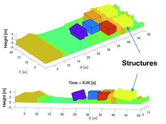
Numerical simulation by 3-D model
The optimization function used to estimate the tsunami source faults has multiple local peaks, which makes it difficult to find the global optimal solution. We developed an inversion method using the replica exchange Makov Monte Carlo method to overcome this problem.
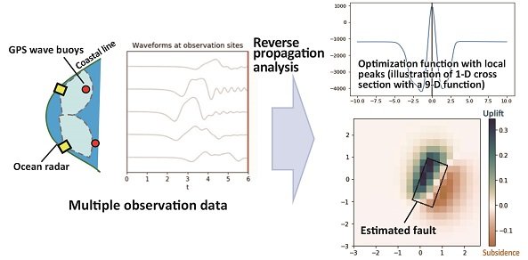
TSUNAMI-source fault estimated from multiple-point observation data
We elucidated the process of how a tsunami goes under at the head of a breakwater, incereased in velocity near the seafloor, and causes scouring, through model experiments and numerical calculations. Related to this, we identified a set of effective methods for caluculating wave forces acting on breakwaters, and verified the stability of a novel scour-suppressing engineering technique, etc. utilizing connected stone filled fiber net. These research findings were used in the design of the breakwaters built near the mouth of Urado Bay, and patents were obtained on the scour-suppression engineering method. We also elucidated the process of how a tsunami-induced swirl could entrap a human body, as well as the buoyancy necessary for suppressing such entrapment.
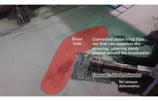
Scour suppression by installation of connected stone filled fiber net
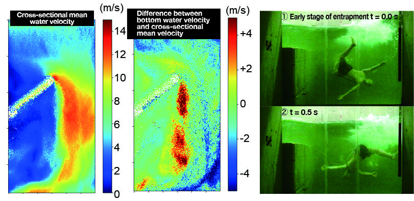
Calculation of water verocity at the breakwater head Entarpment by tsunami
We have developed a free-surface boundary model for the particle methods. This model can appropriately treat unphysical voids generated inside the water under the wave breaking, which are inevitably given in the single phase flow simulations by the N-S solvers. In addition, a new wave generation model has been developed for more easy setups of wave boundaries including connection to other planar 2-D simulations. This model works at any given uniform depth but also along a slope facilitating wave deformations. Hence, the method is expected to drastically improve the computation efficiency by focusing its computation area around the target structure.

Creating technologies that Contribute to the World
National Institute of Maritime, Port and Aviation Technology
Port and Airport Research Institute
3-1-1 Nagase,Yokosuka City, Kanagawa Prefecture, 239-0826 Japan Phone +81-46-844-5010
Copyright © Port and Airport Research Institute. All rights reserved.