
Major Research 4B Research on Coastal and Estuarine Processes
Background and Objectives
PARI'ss research activity of littoral drift was started to examine the critical water depth of sediment movement for harbor planning. Now, prevention methods against sedimentation and also siltation are proposed. However, in Japan, sedimentation and siltation are still progressing in some ports, and in other countries which aim to expand their infrastructure overseas, a much greater amount of siltation than in Japan is projected. Countermeasures against such sedimentation and siltation problem have been inadequate.
On the other hand, beaches are valuable as they provide protection, environment and utilization functions. However, the area of beaches has been decreasing since the era of rapid economic growth, and is still shrinking at a rate of 1.6 km² per year. Various countermeasures have been taken to prevent such coastal erosion, and as a result, the beach area has increased at some coasts. Nevertheless, global warming is expected to cause more severe coastal erosion. In addition, when remote islands and overseas are taken into account, it is important to maintain not only beaches but also coral-reef coasts.
Therefore, in the themes of this study, we aim to maintain the following under future climate change: natural coastline geometry including beaches, mangrove coasts, and coral-reef coasts; and artificial coastline geometry including navigation channels and harbor basins, which support logistics. We will also estimate changes in coastal-erosion and sedimentation phenomena assuming the progress of global warming, and then propose countermeasures against those changes. Also, we will clarify siltation processes in the estuaries of large rivers, mangroves and intertidal zone in the Asian countries, and then propose countermeasures against such phenomena.
Research Topics
Our researches and developments for coastal protection and maintenance of waterways and mooring basins are as follows:
We will analyze long-term measurement data of the Hasaki coast and conduct short-term, intensive, on-site observation of how beaches respond to different sea levels. Through this, we will understand beach-response mechanisms to sea level rise, and will develop methods of predicting future beach morphology. We will take into consideration the spatial scale of not only the Hasaki coast but also global, and predict long-term coastal changes (including natural sand coasts, sand coasts protected by structures, coral-reef coasts, and pebble coasts) along with variations of coastal disaster risks. In addition, we will develop hybrid beach-maintenance methods, which minimize structure volume and actively introduce sand bypasses, and propose effective beach maintenance methods that account for the disaster risks.
Regarding sediment transport which accompanies port utilization, we will expand the scope of our research to include estuaries of large rivers, mangroves, and intertidal zones over-seas. Then, we will develop monitoring method for topographic change which address regional characteristics and understand the dynamics of topographic changes. In addition, we will examine strategies to reduce siltation and sedimentation and will develop the efficient maintenance methods of navigation channels and harbor basins as well as conservation of the surrounding environment of port and harbor facilities.
Activities in FY 2019
For the development of a method for predicting beach morphological changes along with climate change, we used the shoreline change model, which has been developed based on the observation data obtained at the Hasaki coast, and applied it to Omotehama Beach and Ocean Beach. In addition, we started organizing the beach morphological change data in France and the future scenario data for predicting the future coastal change in collaborating with French researchers.
As for observation at the Hazaki Oceanographical Research Station and the development of a coastal topographic change prediction model, we continuously conducted on-site observation of wind, waves, currents, and topographic changes at the Hazaki Oceanographical Research Station. In addition, we performed calculations to estimate topographic changes that would arise around structures, using the topographic change prediction model.
As for the study on the transportation of sediments around estuaries and their deposition processes in navigation channels and turning basins, we developed and applied a numerical model that can simulate the sediment transport caused by waves and tidal currents to actual coastal areas in Java Sea, Indonesia. In addition, we examined the dynamic characteristics of fluid muds, which have been observed in the Java sea and the Niigata Port, and the prevention methods for minimizing harbor siltation with the fluid mud.
As for the applicability of airborne laser bathymetry for topographic monitoring in coastal areas, we studied survey methods to reduce data losses caused by turbid seawater and white foam. In addition, we developed a data reading program that could directly analyze waveform data of laser reflection intensity.
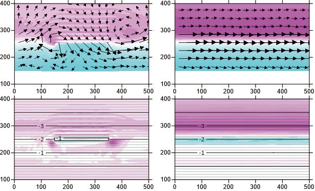
Calculation of currents with and without a submerged breakwater, and topographic change (with oblique waves with a height of 1 m and a cycle of 6 s)
Left: with a submerged breakwater installed on the seabed 2 m below sea level, with its top surface 1 m below sea level
Right: without any submerged breakwater
Top: Currents (arrows) and the mean sea level (light blue indicates elevation)
Bottom: Topographic change (red indicates areas of erosion)
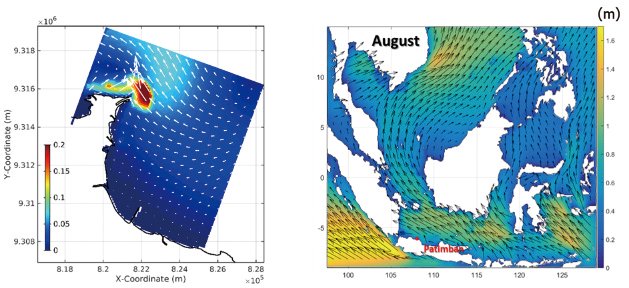
Application of the sediment transport model around the Patimban Coast, Indonesia
(Left) Simulated tidal current field
(Right) Simulated wave field (arrows indicate wind direction and velocity; colors indicate significant wave heights)

Creating technologies that Contribute to the World
National Institute of Maritime, Port and Aviation Technology
Port and Airport Research Institute
3-1-1 Nagase,Yokosuka City, Kanagawa Prefecture, 239-0826 Japan Phone +81-46-844-5010
Copyright © Port and Airport Research Institute. All rights reserved.