
Major Research 3A Research on Development and Utilization of Oceans
Background and Objectives
Since the 1960s, the importance of marine utilization and development has been pointed out. Various approaches for this purpose have been taken, but the progress remains inadequate. One of the reasons is the lack of infrastructure at sea as a hub. Therefore, marine hub ports should be constructed on remote islands including Minamitorishima Island and Okinotorishima Island to promote marine utilization and development.
However, these remote islands are surrounded by severe sea wave environment and severe sea climate for port construction which are different from those of general ports in main islands. Further technological development is required to ensure smooth ship berthing, cargo-handling, and port construction.
Therefore, in this research theme, we will make maximum use of previously accumulated knowledge regarding waves, sea-bed soils, port structures, and port construction to construct ports on remote islands, and will also promote marine utilization and development. Specifically, we will clarify the characteristics of waves in isolated reef areas, and will develop a new mooring system for ships. We will also develop technologies for downsizing and reducing the weight of underwater acoustic video cameras, as well as utilization and development.
Research Topics
Research and development comprises the following two subthemes:
- Research on port construction and management in remote islands
We will develop a numerical model for wave transformations on continental shelf boundaries and around isolated islands. We will also propose a technology to create calm water areas against wave propagation and long-period waves around isolated reefs. At the same time, we will develop a new mooring system applicable to remote islands to improve cargo-handling efficiency for ships. - Research on infrastructure technology for utilization and development of oceans
We are trying to downsize and lighten underwater acoustic video cameras, and will also develop an unmanned underwater construction system to construct marine infrastructure. In addition, we will propose environmental conservation technologies utilizing calcifiers.
Activities in FY 2019
For the research on wave-controlling technology that can be applied to isolated coral reef sea areas, we conducted planar model experiments to study the characteristics of wave transformation that normally occurs in isolated coral reefs, including how wave transformation occurs differently in relation to changing sea levels by tide, and also confirmed the reproducibility of the aforementioned phenomenon using high-resolution Boussinesq calculations. In addition, we corrected the calculation result based on what we had learned in those experiments as needed, and developed a tool that would enable us to estimate and display the spatial distribution of waves and currents over isolated coral reefs for various wave and current conditions that normally arise.
For the technological development of the new mooring system for ships in ports, we suggested measures for resolving the previously identified technical issues with the aforementioned system, for application to remote islands, and also summarized our research findings obtained thus far.
For the research on machine guidance technology used for underwater excavator, we conducted independent-element testing of moundleveling attachment in actual sea areas, to verify the usability of the additional technology for remote operation. In addition, we evaluated a remote operation support system that integrated external measurement sensors and the attachment into machine guidance, and tested its usability by applying it to caisson mounds in Hirara Port.
For the development of the next-generation acoustic imaging system, we conducted experiments on dredging and bottom mud replacement works in actual work areas. As for acoustic video cameras, we applied detailed adjustments as needed for each work type, and removed the strong noise affecting the captured images originating from the power supply in order to improve the image quality. In addition, as for the acoustic image viewing system, we created application software dedicated to each work type and also developed a viewer that updates the image along with the progress of the work being conducted, which enabled us to determine when the current seafloor height achieved the targeted value.
For the development of analytical methods applicable to the topographic dynamics of carbonate islands, we conducted GNSS surveys, photographic surveys using RTK-equipped drones, multi-beam sounding, aerial photography using a combination of visible light and NDVI cameras, sediment and benthic organism sampling, seafloor topography surveys using green-laser drones, and surveys of coral larvae. In addition, we analyzed factors that facilitate topographical changes, developed prediction methods, studied the relation between coral growth and the surrounding environmental conditions, and developed a method using deep learning that could automatically determine the distribution of reef-forming organisms and their levels of activity.
For the study of floating breakwaters equipped with a wave-power generation function, we conceptually evaluated the configuration of wave-power generation devices that would be integrated into floating breakwaters, and performed numerical calculations to examine the optimal shape of such breakwaters while taking into account the wave-dissipating capability of the wave-power generation devices.
For the study of methods for calculating wave forces acting on offshore wind power plants, we evaluated the stability of the numerical calculation using CADMAS-SURF while varying the mesh size and time interval, so that we could calculate the wave force from the velocity and the acceleration of the water particles of progressive waves.
For the study of wave force calculation methods applicable to offshore wind power plants, we reviewed the current designs of offshore wind power plants built on pile foundations, conducted repeated horizontal loading tests on piles set in saturated sandy ground in a large soil tank, and also conducted repeated horizontal loading tests on piles set in saturated clay ground at actual operation sites. Furthermore, we developed a numerical analysis code that could demonstrate the pile-driving (installation) process.
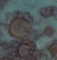
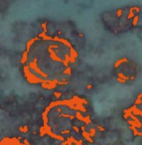
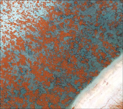
AI-powered automatic coral detection utilizing machine learning
- Based on a sample image (top left), a correct (labeled) image (bottom left) is created.
- Based on the labeled image, teaching data is created.
- Machine learning occurs based on the teaching data.
- Coral areas are automatically detected on the target image (right).

Creating technologies that Contribute to the World
National Institute of Maritime, Port and Aviation Technology
Port and Airport Research Institute
3-1-1 Nagase,Yokosuka City, Kanagawa Prefecture, 239-0826 Japan Phone +81-46-844-5010
Copyright © Port and Airport Research Institute. All rights reserved.