
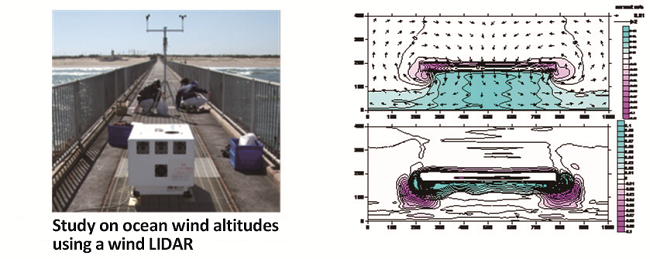
Observation of ocean upper wind at the tip of the observation pier (left) and computation data indicating the mean sea level, nearshore currents, and numerical result of topographical changes near submerged breakwaters (right)
Major Research 4B Research on Coastal and Estuarine Processes
Background and Objectives
PARI'ss research activity of littoral drift was started to examine the critical water depth of sediment movement for harbor planning. Now, prevention methods against sedimentation and also siltation are proposed. However, in Japan, sedimentation and siltation are still progressing in some ports, and in other countries which aim to expand their infrastructure overseas, a much greater amount of siltation than in Japan is projected. Countermeasures against such sedimentation and siltation problem have been inadequate.
On the other hand, beaches are valuable as they provide protection, environment and utilization functions. However, the area of beaches has been decreasing since the era of rapid economic growth, and is still shrinking at a rate of 1.6 km² per year. Various countermeasures have been taken to prevent such coastal erosion, and as a result, the beach area has increased at some coasts. Nevertheless, global warming is expected to cause more severe coastal erosion. In addition, when remote islands and overseas are taken into account, it is important to maintain not only beaches but also coral-reef coasts.
Therefore, in the themes of this study, we aim to maintain the following under future climate change: natural coastline geometry including beaches, mangrove coasts, and coral-reef coasts; and artificial coastline geometry including navigation channels and harbor basins, which support logistics. We will also estimate changes in coastalerosion and sedimentation phenomena assuming the progress of global warming, and then propose countermeasures against those changes. Also, we will clarify siltation processes in the estuaries of large rivers, mangroves and intertidal zone in the Asian countries, and then propose countermeasures against such phenomena.
Research Topics
Our researches and developments for coastal protection and maintenance of waterways and mooring basins are as follows:
We will analyze long-term measurement data of the Hasaki coast and conduct short-term, intensive, on-site observation of how beaches respond to different sea levels. Through this, we will understand beachresponse mechanisms to sea level rise, and will develop methods of predicting future beach morphology. We will take into consideration the spatial scale of not only the Hasaki coast but also global, and predict long-term coastal changes (including natural sand coasts, sand coasts protected by structures, coral-reef coasts, and pebble coasts) along with variations of coastal disaster risks. In addition, we will develop hybrid beach-maintenance methods, which minimize structure volume and actively introduce sand bypasses, and propose effective beach maintenance methods that account for the disaster risks.
Regarding sediment transport which accompanies port utilization, we will expand the scope of our research to include estuaries of large rivers, mangroves, and intertidal zones over-seas. Then, we will develop monitoring method for topographic change which address regional characteristics and understand the dynamics of topographic changes. In addition, we will examine strategies to reduce siltation and sedimentation and will develop the efficient maintenance methods of navigation channels and harbor basins as well as conservation of the surrounding environment of port and harbor facilities.
Activities in FY 2018
We conducted an on-site investigation of the characteristics of sediments in areas of with a sudden change of depth in Niigatanishi Port (in December). We also conducted experiments to understand the behavior of turbid water in dredged areas of a port and examined how effective turbulence control would be for suppressing sedimentation and siltation. We also conducted a joint investigation with BPPT, an Indonesian government agency, pursuant to the research cooperation agreement that had been executed between the parties.
As for the applicability of airborne laser bathymetry for topographic monitoring in coastal zones along the seashore, we conducted aerial surveys of the area encompassing Hasaki Oceanographical Research Station (HORS), the surrounding seashore, and Hasaki fishing port using green laser (on August 27th), checked the status of acquiring sea floor topography data under turbid seawater conditions and also surveyed the sea floor topography around structures along the coastline. In addition, we surveyed the same area at different times with varying sea levels and have been using the acquired data to examine analytical methods that utilize different breaking points of waves to reduce missing survey data that is caused by the white foam that forms as waves break.
For the observation of coastal geographical feature change and malfunction of sedimentation control system in considered with influence of global warming, we carried out continuous on-site observations of the wind, waves, flow, and topographical changes at HORS. In addition, we used beach morphological data of the U.S. West Coast to examine the applicability of the shoreline change model. We also improved the computation model for predicting topographical changes around submerged breakwaters, around which the fields of waves and flow shift in a complex manner due to sudden wave-breaking phenomena.
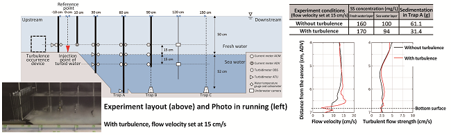
Experiment on the behavior of turbid water flowing into a dredged area inside a port
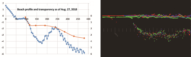
Distribution of seafloor topography and transparency data from the shore into the ocean (left) and aerial laser survey data taken at different times with varying sea levels (right), as observed from HORS

Creating technologies that Contribute to the World
National Institute of Maritime, Port and Aviation Technology
Port and Airport Research Institute
3-1-1 Nagase,Yokosuka City, Kanagawa Prefecture, 239-0826 Japan Phone +81-46-844-5010
Copyright © Port and Airport Research Institute. All rights reserved.