
Major Research 4A Research on Enhancement and Utilization of Coastal Ecology
Background and Objectives
Rich ecosystems in coastal zones include tidal flats, seagrass meadows, and coral reefs. Coastal zones are valuable places for the global environment. However, during the era of rapid economic growth, intense socio-economic activities caused the deterioration of water quality in coastal inner bays and enclosed waters, resulting in ecosystem damage. Thanks to subsequent countermeasures, water quality has gradually been improving in some coastal zones; however, recovery of the coastal zone environment including ecosystems remains a formidable challenge.
On the other hand, new challenges include the utilization of coastal zone functions for mitigating climate change, as well as countermeasures against large-scale oil spill incidents from maritime industrial complexes and other facilities.
Therefore, in the themes of this research, we will conduct research and development with the following goals: further restoration of the coastal zone environment, coastal zone utilization for climate change mitigation, and establishment of technologies to counter large-scale oil spill incidents.
Research Topics
Research and development comprises the following three subthemes:
1.Research on coastal-ecosystem utilization
Regarding ecosystem-based countermeasures against the impacts of climate change, we will conduct research on climate change mitigation including carbon and atmospheric CO₂ uptake, both of which utilize ecosystems (blue carbon) under various conditions including remote islands such as Minamitorishima Island. In addition, we will expand our technological development internationally. We will also develop a technology to create coastal ecosystems which suffer less damage due to earthquakes and tsunamis and which recover rapidly. Through such technologies, we can continuously reap the benefits of the ecosystem.
2.Research on the water-environment simulation and analysis in inner-bay
We will develop the following methods regarding the acquisition and utilization of environment observation data: a new method of analyzing marine monitoring data covering currently operating ferries and monitoring posts and others; and a new method of observing parameters for which common methods cannot obtain adequate results. We will also re-analyze existing underutilized environmental data, and will use multifunctionalized GPS wave-observation buoys to continuously observe areas for which environmental data has not been obtained. In addition, we will integrate weather/marine/ecosystem models and utilize in real time the environmental observation data. Through these means, we will develop a system which comprehensively predicts problems that frequently occur in inner bays, including red tides, blue tides, and hypoxia.
3.Research on countermeasure technologies against sea oil spill
Regarding technologies for dealing with spilled oil, in addition to developing technologies to resolve conventional on-site challenges, we will conduct new research and development on the following: oil-gathering equipment loaded on next-generation oil-recovery ships; and systems which comprehensively recover or treat oil and which can address large-scale oil spill incidents. In addition, we will establish an information system for the risk management of oil pollution based on simulation technology, understand the behavior and mechanisms of oil spilled from dangerous facilities in waterfront areas due to natural disasters including earthquakes and tsunamis, and conduct research and development of quantitative prediction techniques and mitigation techniques for spilled oil. Through such approaches, we will develop innovative countermeasure techniques against oil pollution and improve the ability to respond oil pollution.
Activities in FY 2018
For the global estimates of the efficacy of blue carbon as a means of mitigation and adaptation to climate change, we estimated the amounts of current CO₂ absorption by blue-carbon ecosystems and other shallow coastal ecosystems, on a global scale for the first time in the world, and also for the whole of Japan, that is crucial for developing government policies on this topic. We also presented these findings at the side event of the 24th Conference of the Parties (COP24) of the United Nations Framework Convention on Climate Change (UNFCCC).
For the development of integrated prediction and assessment method of coastal benthic ecology and geoenvironmental dynamics, we improved and further developed the chart for diagnosing the habitat environment of organisms, and used it to obtain the results of integrated assessment and prediction of the link between coastal benthic ecology and geoenvironmental dynamics then compared them to the data acquired during on-site surveys, and verified that the developed integrated methods can consistently assess and predict the relationship between biodiversity and geoenvironmental dynamics as well as the changes in areas where various organisms are distributed.
For the research on cross-sectional observation and analysis of atmospheric and oceanographic issues at bay mouths, we obtained and examined wind direction and velocity data from Kanaya-maru for atmospheric observation. As for oceanographic observation, we developed a new marine observation system for use aboard Kanaya-maru.
For the development of evaluating procedure for biodiversity referring to spatial scale in coastal areas, we organized information on the characteristics of diversity evaluation methods, and compiled evaluation guidelines that would be suitable for ports and harbors.
For the analytical study of macro-organisms dynamics on a coastal ecosystem simulation, we added a new model applicable to fishes and verified that their data could be computed.
For the study on the mechanisms of coastal current and water environment using data assimilation, we programmed a new data assimilation model into the Ise Bay simulator and verified it through numerical experiments.
We conducted an experimental examination of the feasibility of applying bubble curtains to oil collection equipment, and elucidated that bubble curtains alone would be able to collect spilled oil floating on the surface in an arbitrary location and keep it there, without using conventional-type solid damming elements. We also examined a dispersed fire extinguishing method for extinguishing a fire burning on drifting oil. As for the development of real-time hazard maps indicating oil spills, we converted the server-side scripts into Node.js to enhance scalability, and released them on the PARI website for trial operation as RC.
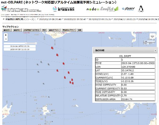
Real-time hazard map of oil spills

Creating technologies that Contribute to the World
National Institute of Maritime, Port and Aviation Technology
Port and Airport Research Institute
3-1-1 Nagase,Yokosuka City, Kanagawa Prefecture, 239-0826 Japan Phone +81-46-844-5010
Copyright © Port and Airport Research Institute. All rights reserved.