
Major Research 1B Research on Mitigation and Restoration of Tsunami Disasters
Background and Objectives
Since the Great East Japan Earthquake in 2011, we have studied stable structures against tsunami overflows and developed a numerical simulation model to predict the drifting of debris generated by the destruction of buildings. However, complex behaviors of tsunami run-up on land and the resulting damages are not fully understood and modeled yet. In addition, regarding a technique for real-time inundation forecast, which is expected to be utilized for evacuation and other purposes, only data from GPS-mounted wave buoys is used; other valuable data is not fully utilized yet.
Therefore, we are aimed for changing disaster prevention and reduction countermeasures into a pre-disaster stage from post-disaster one, and will conduct research to establish resilient coastal zones which can withstand the most severe tsunamis, i.e., to protect lives against the most severe tsunami, to avoid catastrophic socioeconomic damages, and to enable early recovery and reconstruction.
Research topics
Research and development comprises the following two subthemes:
- Research on ICT-based decision support systems
We have previously developed a system for rapid forecasting of tsunami inundation, which utilizes offshore-tsunami waveforms observed by GPS-mounted wave buoys. For highly reliable tsunami prediction, we will additionally utilize ground deformation data obtained by on-land GPS base stations and remote-sensing information including ocean HF radars, and will refine the system. To ensure the safety of evacuation sites, it is necessary to assess not only tsunami-induced inundation depth but also the tsunami velocity and floating objects to determine the resistance of structures and even to assess fires, which are associated with floating objects. So, we establish an integrated simulation system which can assess these risks.
- Research on the development of tsunami-resistant ports
We will clarify the structures of violent flows, scours around structures induced by large tsunami-overflows, and the influence of drifting objects including ships and vessels on the damages. Then, we will develop a method of designing tsunami-resistant breakwaters and other facilities as well as a method of planning tsunami-resistant ports. We will develop a three-dimensional multi-physics numerical model based on a particle method with fluid-solid interaction, and utilize it as a tool for the design and planning in addition to numerical models we have developed so far. Moreover, we will conduct a large-scale model experiment to validate the robustness and accuracy of the numerical model, and will understand complex tsunami phenomena in port cities.
Activities in FY 2018
For developing a tsunami-fire model for ports, we used the debris behavior model that we had been improving through flume experiments until the previous fiscal year to calculate the inundation and debris drifting that occurred in Yamada Town, Iwate Prefecture as a result of the 2011 Great East Japan Earthquake Tsunami. Improving the calculation accuracy of debris behavior is important for better reproducibility of tsunami run-up areas.
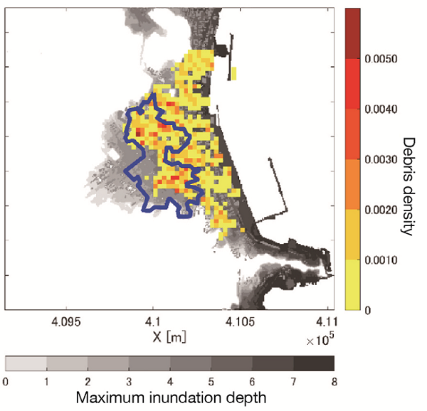
Calculation of tsunami inundation and debris drift
For developing the tsunami forecasting method based on multi-observation data, we analyzed the characteristics of the noise of ocean HF radars and also GPS-mounted wave buoys. In addition, we introduced weighting algorithm for multiple data sets in inverse analysis of tsunami sources, and examined the applicability of this method using synthetic data with obverted noises.
As for the advanced 3-dimensional tsunami inundation simulator, we completed the simulator to calculate the inundation in the hinterland, while taking into account the deformation of protection facilities. We conducted a trial calculation for Otsuchi Town flooded by the 2011 Great East Japan Earthquake Tsunami and the coast of Urado Bay by the Nankai Trough Tsunami. And we also improved the computational efficiency of this simulator and enhanced the visualization function.
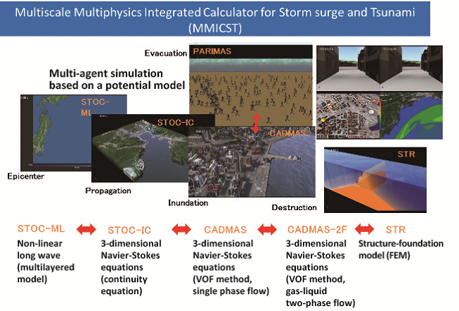
Overview of multiscale multiphysics integrated simulator
For developing the method for estimating local scouring around coastal structures caused by tsunamis, we improved a pressure gradient model that makes up the particle-based simulator, and added a sedimentation model that considers the attachment of sand particles floating in the water to the seabed. As a result, we improved the reproducibility of the simulator for overflows on breakwaters and scouring of the ground behind them.
For applying the particle-based method to the deformation of port and harbor structures caused by tsunamis, we improved the pressure model and also enhanced the precision of the multi-resolution structure model, and also started developing a new coupling model for them. As a result, we enhanced the accuracy of the evaluation of the pressure distribution in plunging breakers and also the impact force that occurs when marine vessels and other floating objects hit the water surface.

Creating technologies that Contribute to the World
National Institute of Maritime, Port and Aviation Technology
Port and Airport Research Institute
3-1-1 Nagase,Yokosuka City, Kanagawa Prefecture, 239-0826 Japan Phone +81-46-844-5010
Copyright © Port and Airport Research Institute. All rights reserved.