
Major Research 4B Research on Coastal and Estuarine Processes
Background and Objectives
PARI's research activity of littoral drift was started to examine the critical water depth of sediment movement for harbor planning. Now, prevention methods against sedimentation and also siltation are proposed. However, in Japan, sedimentation and siltation are still progressing in some ports, and in other countries which aim to expand their infrastructure overseas, a much greater amount of siltation than in Japan is projected. Countermeasures against such sedimentation and siltation problem have been inadequate.
On the other hand, beaches are valuable as they provide protection, environment and utilization functions. However, the area of beaches has been decreasing since the era of rapid economic growth, and is still shrinking at a rate of 1.6 km² per year. Various countermeasures have been taken to prevent such coastal erosion, and as a result, the beach area has increased at some coasts. Nevertheless, global warming is expected to cause more severe coastal erosion. In addition, when remote islands and overseas are taken into account, it is important to maintain not only beaches but also coral-reef coasts.
Therefore, in the themes of this study, we aim to maintain the following under future climate change: natural coastline geometry including beaches, mangrove coasts, and coral-reef coasts; and artificial coastline geometry including navigation channels and harbor basins, which support logistics. We will also estimate changes in coastal-erosion and sedimentation phenomena assuming the progress of global warming, and then propose countermeasures against those changes. Also, we will clarify siltation processes in the estuaries of large rivers, mangroves and intertidal zone in the Asian countries, and then propose countermeasures against such phenomena.
Research Topics
Our researches and developments for coastal protection and maintenance of waterways and mooring basins are as follows:
We will analyze long-term measurement data of the Hasaki coast and conduct short-term, intensive, on-site observation of how beaches respond to different sea levels. Through this, we will understand beach-response mechanisms to sea level rise, and will develop methods of predicting future beach morphology. We will take into consideration the spatial scale of not only the Hasaki coast but also global, and predict long-term coastal changes (including natural sand coasts, sand coasts protected by structures, coral-reef coasts, and pebble coasts) along with variations of coastal disaster risks. In addition, we will develop hybrid beach-maintenance methods, which minimize structure volume and actively introduce sand bypasses, and propose effective beach maintenance methods that account for the disaster risks.
Regarding sediment transport which accompanies port utilization, we will expand the scope of our research to include estuaries of large rivers, mangroves, and intertidal zones overseas. Then, we will develop monitoring method for topographic change which address regional characteristics and understand the dynamics of topographic changes. In addition, we will examine strategies to reduce siltation and sedimentation and will develop the efficient maintenance methods of navigation channels and harbor basins as well as conservation of the surrounding environment of port and harbor facilities.
Activities in FY 2017
In an observation of coastal geographical feature change and generalizing of prediction method in considered with influence of global warming, we elucidated the following: changes in shoreline position are associated with both tide and wave height; the changes occur 36 days after the day when tide becomes highest and 72 days before the day when wave height becomes highest. Also, we investigated a wave breaking model for numerical simulation, which utilizes the Ursell number, which represents the asymmetric characteristics of waves, however, the calculation results regarding breakers on submerged breakwaters and average water-level reduction are sometimes unstable. Therefore, we found that the breaker model requires further improvement.
In a study on sediment transport in estuary and deposition process in navigation channel, we compared the results of an estuary turbidity distribution study conducted around Patimban Coast (August, dry season) with the results from a previous study (February 2017, rainy season), and identified seasonal-variation characteristics of highly dense fluid mud. Also, we conducted on-site studies regarding highly dense turbid water at the time of flowing out within Niigatanishi Port and elucidated the process of accumulation of highly dense fluid mud in dredging areas. In addition, we conducted on-site observations and flume experiments, modeled the amount of fluid mud transport, which depends on mud content in the bottom sediment and other factors, and then verified the model.
In a study on applicability of airborne laser bathymetry for topographic monitoring in coastal zone of sea shore, obtained topography through aircraft sounding utilizing green laser showed good agreement with the cross-section topography through lead sounding, except for areas with many white bubbles caused by wave breaking. Regarding the scouring conditions around piles supporting observation pier of Hazaki Oceanographycal Research Station, correct measurements were made. Although some measurement errors, which appear to be caused by missing sea bottom measurements due to the white bubbles of wave breaking, due to turbidity in deep-water areas and other factors, aircraft sounding accuracy levels are high, showing that aircraft sounding can be an effective method of performing highly accurate topography measurements within breaker zones on a wider and highlydense scale.
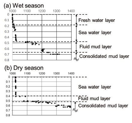
Vertical distribution of bottom-mud densities in rainy season and dry season at Patimban

Creating technologies that Contribute to the World
National Institute of Maritime, Port and Aviation Technology
Port and Airport Research Institute
3-1-1 Nagase,Yokosuka City, Kanagawa Prefecture, 239-0826 Japan Phone +81-46-844-5010
Copyright © Port and Airport Research Institute. All rights reserved.