
Major Research 1B Research on Mitigation and Restoration of Tsunami Disasters
Background and Objectives
Since the Great East Japan Earthquake in 2011, we have studied stable structures against tsunami overflows and developed a numerical simulation model to predict the drifting of debris generated by the destruction of structures. However, complex behaviors of run-up tsunamis on land and the resulting damages are not fully understood and modeled yet. In addition, regarding a technique for real-time inundation forecast, which is expected to be utilized for evacuation and other purposes, only data from GPS-mounted wave buoys is used; other valuable data is not fully utilized yet.
Therefore, we are aimed for changing disaster prevention and reduction countermeasures into a pre-disaster stage from post-disaster one, and will conduct research to establish resilient coastal zones which can withstand the most severe tsunamis, i.e., to protect lives against the most severe tsunami, to avoid catastrophic socioeconomic damages, and to enable early recovery and reconstruction.
Research topics
Research and development comprises the following two subthemes:
1.Research on ICT-based decision support systems
We have previously developed a system for rapid forecasting of tsunami inundation, which utilizes offshore-tsunami waveforms observed by GPS-mounted wave buoys. For highly reliable tsunami prediction, we will additionally utilize ground deformation data obtained by on-land GPS base stations and remote-sensing information including ocean HF radars, and will refine the system. To ensure the safety of evacuation sites, it is necessary to assess not only tsunami-induced inundation depth but also the tsunami velocity and floating objects to determine the resistance of structures and even to assess fires, which are associated with floating objects. So, we will establish an integrated simulation system which can assess these risks.
2.Research on the development of tsunami-resistant ports
We will clarify the places with strong flow, scour around structures induced by large-scale overflows, and the impact of drifting objects including ships and vessels. Then, we will develop a method of designing tsunami-resistant breakwaters and other facilities as well as a method of planning tsunami-resistant ports. In addition to numerical models we have developed so far, we will develop a three-dimensional multi-physics numerical model based on a particle method with fluid-solid interaction as a tool for the design and planning. Moreover, we will conduct a large-scale model experiment to validate the robustness and accuracy of the numerical model, and will understand complex tsunami phenomena in port cities.
Activities in FY 2017
In the development of a tsunami-fire model for ports, the generation, transporting, stopping and accumulating processes of debris must be appropriately taken into account; therefore, we improved a part of the fluid-debris interactions of the existing numerical model. Also, we digitized the location of each debris on video images of past experiments and analyzed the characteristics of the debris motions.
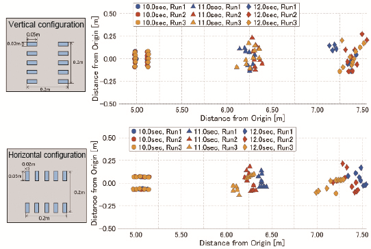
Differences in the motions of debris occurred due to the initial directions
In the development of multi-observation based tsunami forecasting method, we established a method to improve tsunami detection accuracy by combining information on satellite positions and filtering processes through continuous wavelet transform. In addition, we conducted a theoretical analysis to develop a new tsunami source inversion method, which properly weighs several data with different noise characteristics including GPS-mounted wave buoys and ocean HF radars.
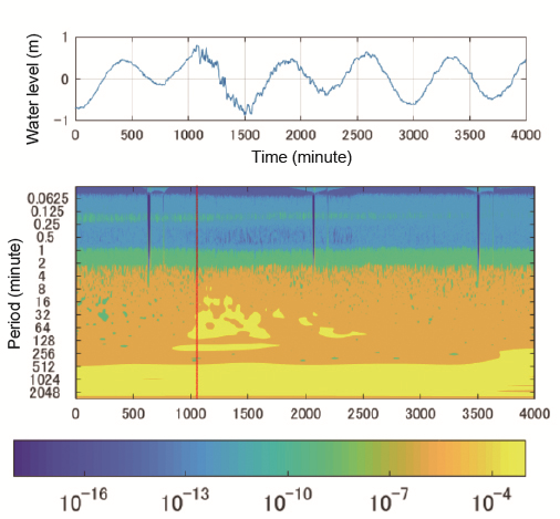
Continuous wavelet analysis on tsunami water-level data
In the development of an advanced 3-dimentional simulation model for tsunami inundation, we introduced a hybrid parallel computation method, which utilizes MPI and OpenMP, to improve the computation efficiency. Also, we verified this simulator in the two cities of Kamaishi and Kochi; moreover, we prepared manuals of this simulator to disclose the source code the next fiscal year, and developed the integrated execution environments including I/O supports tools. In addition, as a method to properly count the performance of protective facilities in various damage levels, we developed an evaluation method utilizing fragility curves. We then applied this method to Tohoku areas and verified using survey data.
In the development of the estimation method for local scour around costal structures due to tsunami, we confirmed the reproducibility in the topography change according to each sediment transformation equation by comparing with hydraulic experiments on bathymetry like a port and with the survey results in and around Hachinohe Port, which was affected by the 2011 Great East Japan Earthquake.

Creating technologies that Contribute to the World
National Institute of Maritime, Port and Aviation Technology
Port and Airport Research Institute
3-1-1 Nagase,Yokosuka City, Kanagawa Prefecture, 239-0826 Japan Phone +81-46-844-5010
Copyright © Port and Airport Research Institute. All rights reserved.