
Major Research Study on hyper intense typhoon wind, storm and surge water characteristics in Japanese bays
Very intense Typhoon Haiyan struck the Philippines with a central pressure of 895 hPa, causing devastating wind, storm surge and wave disasters. Japan was also hit by Typhoon Muroto with a central pressure of 911 hPa. When taking future climate changes into account, it is not unrealistic that a Haiyan-level typhoon may strike Japan.
Therefore, in this research, we reviewed previous typhoons and storm surges. We used Kagoshima Bay as an example to characterize waves, storm surges and winds assuming that a Haiyan-level typhoon strikes Japan.
The model typhoon had already been set based on the MLIT's Guide of Mapping Storm Surge Flood Areas. In 2016, we set a Haiyan-level model typhoon as the most intense typhoon, added it to the existing model typhoons, and estimated the waves and storm surges. The results showed that a storm surge of 3 m or higher would develop in Kagoshima Bay, which would surpass the existing highest value. In Kagoshima Port, which is located in the middle of the bay, a track of the Haiyan-level typhoon can bring the maximum wave height and storm surge. The peak of the wave height appeared first, and then those of the wind velocity and the storm surge followed.
These results are basic knowledge when setting design wave and water level based on a scenario typhoon, which will be introduced into the design standard for port facilities.
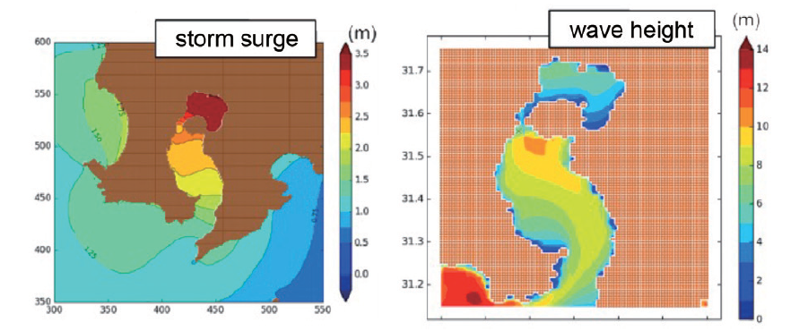
Maximum storm surge and wave height caused by a Haiyan-level typhoon

Creating technologies that Contribute to the World
National Institute of Maritime, Port and Aviation Technology
Port and Airport Research Institute
3-1-1 Nagase,Yokosuka City, Kanagawa Prefecture, 239-0826 Japan Phone +81-46-844-5010
Copyright © Port and Airport Research Institute. All rights reserved.