
Major Research 4B. Research on Coastal and Estuarine Processes
Background and Objectives
PARI's research activity of littoral drift was started to examine the critical water depth of sediment movement for harbor planning. Now, prevention methods for harbor sedimentation due to sand and also siltation due to silt are proposed. However, in Japan, sedimentation is still progressing in some ports, and in countries which aim to expand their infrastructure overseas, a much greater amount of siltation than in Japan is projected at some channels. Countermeasures against such sedimentation and siltation problem have been inadequate.
On the other hand, beaches are valuable as they provide protection, environment and utilization functions. However, the area of beaches has been decreasing since the era of rapid economic growth, and is still shrinking at a rate of 1.6 km² per year. Various countermeasures have been taken to prevent such coastal erosion, and as a result, the beach area has increased at some coasts. Nevertheless, global warming is expected to cause more severe coastal erosion. In addition, when remote islands and overseas are taken into account, it is important to maintain not only beaches but also coral-reef coasts.
Therefore, in the themes of this study, we aim to maintain the following: natural coastline geometry including beaches, mangrove coasts, and coral-reef coasts; and artificial coastline geometry including channel and harbor. We will also estimate changes in coastal-erosion and sedimentation phenomena assuming the progress of global warming, and then propose countermeasures against those changes. Also, we will clarify siltation in the estuaries of large Asian rivers, mangroves and tidelands, and then propose countermeasures against such phenomena.
Research topics
Our researches and developments for the conservation of beaches and maintenance of ports are as follows:
We will analyze long-term measurement data of the Hasaki coast and conduct short-term, intensive, on-site observation of how beaches respond to different sea levels. Through this, we will understand beach-response mechanisms to sea level rise, and will develop methods of predicting future beach morphology. We will take into consideration the spatial scale of not only the Hasaki coast but also global, and predict long-term coastal changes (including natural sand coasts, sand coasts protected by structures, coral-reef coasts, and pebble coasts) along with variations of coastal disaster risks. In addition, we will develop hybrid beach-maintenance methods, which minimize structure volume and actively introduce sand bypasses, and propose effective beach maintenance methods that account for the disaster risks.
Regarding sediment transport which accompanies port utilization, we will expand the scope of our research to include estuaries of large rivers, mangroves, and tidelands overseas. Then, we will develop monitoring method for topographic change which address regional characteristics and understand the dynamics of topographic changes. In addition, we will devise strategies to reduce siltation and will develop the efficient maintenance methods of channels and harbors as well as conservation of the environment of areas surrounding port facilities.
Activities in FY 2016
Regarding field surveys of changes in coastal morphology due to sea level rise and generalized future prediction methods, we consistently collected on-site data from the Hazaki Oceanographical Research Station. Based on on-site data, we also conducted analyses to clarify the long-term beach changes and used numerical simulation to establish a model for simulating changes in geometry around structures. In addition, we used on-site data to understand long-term shoreline changes to sandy coasts where large-scale disposal of dredged sediment had been made in the past.
To clarify mechanisms of sediment transportation in estuaries and accumulation in channels and harbors, in Japan, we conducted on-site surveys regarding fluid-mud transportation and on-site experiments of bottom-mud movement in estuaries and tidelands around Kumamoto Port. Overseas, we worked with a collaborative research institution in Indonesia regarding survey plans to identify the processes of transportation of fine mud, which is a characteristic of estuaries in Southeast Asia. Then, we conducted on-site surveys of the dispersion of turbid river water in estuaries around Patimban Coast in East Java and succeeded in collecting data for evaluating the distribution characteristics of bottom-mud densities.
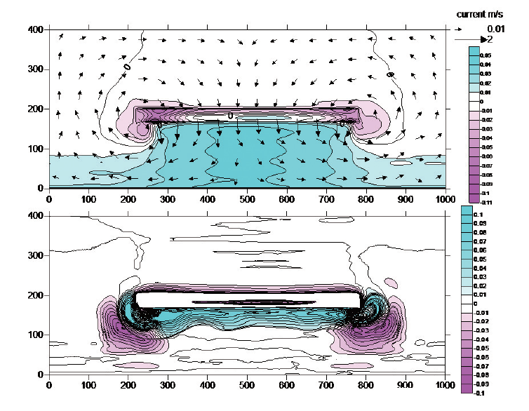
Example of simulation results of topography changes around submerged breakwaters
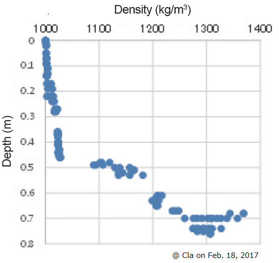
Example of measurements of vertical distribution of density in Patimban

Creating technologies that Contribute to the World
National Institute of Maritime, Port and Aviation Technology
Port and Airport Research Institute
3-1-1 Nagase,Yokosuka City, Kanagawa Prefecture, 239-0826 Japan Phone +81-46-844-5010
Copyright © Port and Airport Research Institute. All rights reserved.