
Major Research 1B. Research on Mitigation and Restoration of Tsunami Disasters
Background and Objectives
Since the Great East Japan Earthquake in 2011, we have studied stable structures against tsunami overflows and developed a numerical simulation model to predict the drifting of debris generated by the destruction of structures. However, complex behaviors of run-up tsunamis on land and the resulting damages are not fully understood yet. Any method of estimating them has not been developed. In addition, regarding a real-time technique for inundation forecast, which is expected to be utilized for evacuation and other purposes, only data from GPS-mounted wave buoys is used; other valuable data is not fully utilized yet.
Therefore, we will conduct research to establish resilient coastal zones which can withstand the most severe tsunamis, i.e., to protect lives against the most severe tsunamis, to prevent catastrophic socioeconomic damages, and to enable early recovery and reconstruction. The purpose is to change disaster prevention and reduction countermeasures into a pre-disaster stage from post-disaster one.
Research topics
Research and development comprises the following two subthemes:
1.Research on ICT-based decision support systems
We have previously developed a system for rapid forecasting of tsunami inundation, which utilizes offshore-tsunami waveforms observed by GPS-mounted wave buoys. For highly reliable tsunami prediction, we will additionally utilize ground deformation data obtained by on-land GPS base stations and remote-sensing information including ocean HF-radars, and will refine the system. To ensure the safety of evacuation sites, it is necessary to assess not only tsunami-induced inundation depth but also the tsunami velocity and floating objects to determine the resistance of structures and even to assess fires, which are associated with floating objects. So, we will establish an integrated simulation system which can assess these risks.
2.Research on the development of tsunami-resistant ports
We will clarify the places with strong flow, scour around structures induced by large-scale overflows, and the impact of drifting objects including ships and vessels. Then, we will develop a method of designing tsunami-resistant breakwaters and other facilities as well as a method of planning tsunami-resistant ports. In addition, we will develop a three-dimensional multi-physics numerical model based on a particle method with fluid-solid interaction as a tool for the design and planning. Moreover, we will conduct a large-scale model experiment to validate the robustness and accuracy of the numerical model, and will understand complex tsunami phenomena in port cities.
Activities in FY 2016
In the development of a tsunami-fire model for ports, we modeled marine fires at Kesennuma Bay that were induced by the 2011 great east Japan earthquake tsunami. The model applied to Tsu-Matsusaka Port in Mie Prefecture to assess a scenario tsunami including the drifting of cars and fishing vessels, dispersion of spilled oil, and ignition/combustion/extinguishment of debris fires. We will investigate fires in urban areas. This newly-developed model is expected to help disaster-prevention planning with the consideration of tsunami fires.
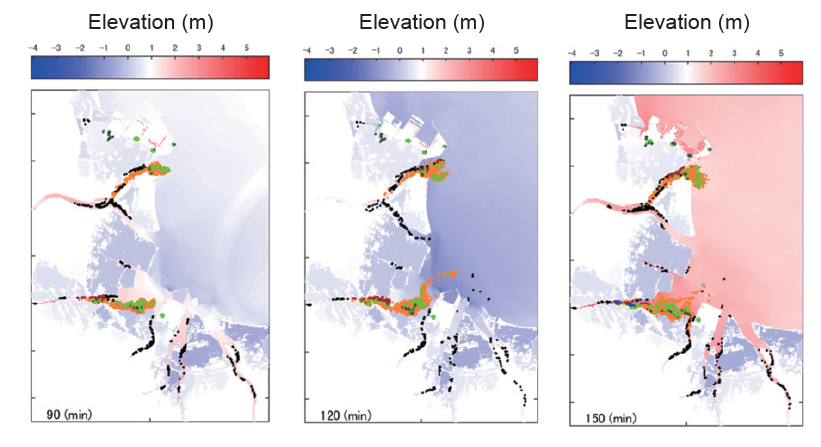
Numerical simulation of tsunami fires. Yellow green dots indicate drifting cars and fishing vessels. Dark green dots indicate stopped ones. Orange dots indicate spilled oils. Black, red, blue dots indicate debris which are in the state of pre-ignition, burning, post-extinguishment, respectively.
In the development of an ocean-earth coupling model for tsunami propagation, we add the following effects to a conventional tsunami model: wave dispersion, seawater compressibility, elastic deformation of solid earth under the ocean, and the deformation of gravity potential induced by tsunami generation and propagation. The new model improved the accuracy of waveforms especially for trans-oceanic far-field tsunamis. The model can be connected to existing tsunamisimulator STOC to assess the inundation in coastal areas.
In the development of an advanced three-dimensional simulation model for tsunami inundation, we established a numerical model which consistently simulates tsunami generation, propagation from the source to the coast, deformation of protection facilities, and tsunami run-up on backlands. With this numerical model, we can understand in detail when protection facilities deform and how inundated areas spread in a target area. Hereafter, we will improve the computational efficiency, accumulate case studies, and prepare to open the model to public.
In the development of the estimation method for local scour around coastal structures due to tsunami, we added a duration time effect to the conventional equation with a single parameter of overflow depth, on the basis of experimental results. Moreover, the numerical model of the particle method successfully reproduced scouring phenomena. Hereafter, we will investigate the scouring around corners and ends of breakwaters.

Scouring experiment (A) and numerical simulation with particle method (B)

Creating technologies that Contribute to the World
National Institute of Maritime, Port and Aviation Technology
Port and Airport Research Institute
3-1-1 Nagase,Yokosuka City, Kanagawa Prefecture, 239-0826 Japan Phone +81-46-844-5010
Copyright © Port and Airport Research Institute. All rights reserved.