
Major Research 4B Research on Coastal and Estuarine Processes
Background and Objectives
Sediment transport research at the Port and Airport Research Institute began with the study of the depth of movement limit to prevent navigation channel burial, currently the research has shown that themethod of preventing channel burial is not only for sand, but also for silt. However, in Japan there are still ports and harbors that are in the process of being buried. In addition, overseas, there are ports and harbors where much more sediment is expected to be deposited than in Japan, and the technology to deal with the burial of these navigation channels and anchorage is not sufficient. Meanwhile, many precious natural beaches were lost during the period of rapid economic growth, and this negative trend is yet to be reversed. Although the many benefits that beaches yield for protection, environmental conservation, and human use are clearly recognized, and they are being restored on certain coastlines by taking measures to suppress coastal erosion, global warming is also expected to exacerbate coastal erosion in the future. Also, when remote islands and overseas are taken into account, it is important to maintain not only beaches but also coral-reef coasts. PARI is currently focusing on identifying means for effectively preserving both natural coastal topography, such as beaches, mangrove shorelines, and coral-reef coasts, and artificial coastal features, including navigation channels and anchorage that are crucial for logistics, despite the ongoing trend of climate change. In addition, PARI is working to predict key changes in coastal erosion as well as sedimentation and siltation affecting navigation channels and anchorage, and to suggest measures to effectively address these issues while assuming that the trend of global warming might persist. Furthermore, we will clarify siltation processes in the estuaries of large rivers, mangroves and intertidal zone in the Asian countries, and then propose countermeasures against such phenomena.
Research Topics
For research and development on the formation and preservation of coastal topography, we are focusing on the following:
For the development of a global-scale prediction method of beach morphological changes induced by global climate change, we are generalizing the parameters of an existing equilibrium-based shoreline change model and applying the model to predict future shoreline changes in various beaches in response to the future climate change scenarios. We are also developing the beach profile change model using deep neural networks.
For the observation activity at the Hazaki Oceanographical Research Station (HORS) and the development of a coastal topographical change prediction model, we are continuously conducting on-site observations at the HORS while examining the predicting methods for topographical changes that would arise around the ports and coastal areas.
For the development of sediment transport control methods to mitigate channel and anchorage siltation, we are incrementally applying the sand-mud-mixture sediment model to actual coastal and harbor areas. For this purpose, we are developing a simulation system that reflects the sediment dynamic characteristics of each sea area to be studied, and to study measures to mitigate the amount of sediment deposited in the sea.
Activities in FY 2021
For the development of a global-scale prediction method of beach morphological changes induced by global climate change, we have developed a beach profile change model using deep learning and reproduced temporal beach profile changes and temporal components obtained from REOF analysis of beach profiles.
For the observation activity at the HORS and the development of a coastal topographical change prediction model, we have developed a monitoring method of wave directions with photographic data obtained from our oceanographic observation cameras. We also examined our coastal topographical change prediction model that can consider thetopographical changes due to breaking waves.
To elucidate the mechanisms of sediment transport near estuaries and accumulation in navigation channels and anchorage, a bottom sediment transport tool was established for the Patimbang coast of Indonesia, taking into account the variation of external wave forces due to changes in the wind field specific to the Java Sea (i.e., monsoons and onshore-offshore breezes), and further improved into a numerical tool that can take into account the detailed geometry of port facilities (navigation channel dredging topography, outer facilities, etc.).
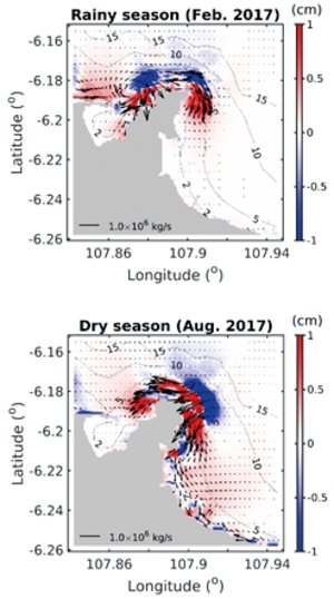
Sediment transport simulation, reflecting the typical characteristics of changes in wind fields in a tropical region

Creating technologies that Contribute to the World
National Institute of Maritime, Port and Aviation Technology
Port and Airport Research Institute
3-1-1 Nagase,Yokosuka City, Kanagawa Prefecture, 239-0826 Japan Phone +81-46-844-5010
Copyright © Port and Airport Research Institute. All rights reserved.