
Sediment budget on an intertidal flat at the mouth of the Shirakawa River, Japan
Sediment movements on intertidal flats have strong impacts on valuable but vulnerable ecological systems of the flats and the nearshore sediment systems on the adjacent beaches. Sediment movements on flats are more complicated than those on sandy beaches because sediments on flats are composed of sand and silt, and sediments supplied from rivers are transported by waves and tidal currents. However, sediment budgets on intertidal flats are less understood than those on sandy beaches. The objective of this study is to investigate the sediment budgets on an intertidal flat at the mouth of the Shirakawa River in Japan using bathymetry, river discharge and wave data.
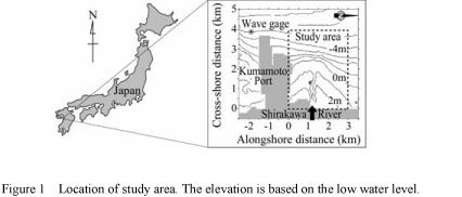
Figure 1 shows the study area; the alongshore distance of the study area is 3.5 km and the cross-shore distance is 4.0 km. The averaged offshore wave height is 0.33 m; the offshore wave data were obtained near the Kumamoto Port as shown in Figure 1. The mean spring tidal range is 4.5 m, macrotidal. The investigated period from 1976 to 2002 was divided into four short periods according to the dates when surveys were conducted, and sediment budget quantities during the short periods including the volume changes, the amount of sediment supply from the river and the sediment transport rate due to waves and tidal currents were estimated.
The volume changes QV were estimated on the basis of bathymetry data, which were obtained in 1976, 1978, 1998, 2000, and 2002.
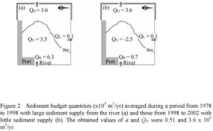
The sediments that caused the bathymetric changes of the flat are probably composed of sand and silt. In this analysis, the amount of sediments that were discharged from the Shirakawa River and contributed to the bathymetric changes QR was assumed to be proportional to the amount of silts from the river QSILT; the assumption is expressed as QR=aQSILT, where a is a coefficient. Because the relationship between QSILT and the river discharge is shown by a previous study, QSILT was estimated with the river discharge measured near the river mouth. The value of a was estimated with a method mentioned below.
The sediment transport rate due to waves and tidal currents was divided into two values: longshore sediment transport rate due to waves QL and the other rate QO.
At the north boundary, the longshore sediment transport rate was estimated with a conventional formula on the basis of the offshore wave data. Because the temporal variation of the annually averaged offshore wave height is small, the longshore sediment transport rate was assumed to be constant. The longshore sediment transport rate at the south boundary was assumed to be zero because the main breakwater of the

Creating technologies that Contribute to the World
National Institute of Maritime, Port and Aviation Technology
Port and Airport Research Institute
3-1-1 Nagase,Yokosuka City, Kanagawa Prefecture, 239-0826 Japan Phone +81-46-844-5010
Copyright © Port and Airport Research Institute. All rights reserved.